The Definitive Guide to Flock Camera Locations in the United States
Automated license plate readers have reshaped American policing and suburban surveillance. Below is an exhaustive technical investigation examining how Flock camera locations are selected, how private HOA grids integrate into police dispatch systems, the legal framework governing public disclosure, and step-by-step methodologies for identifying and auditing hardware in your community.
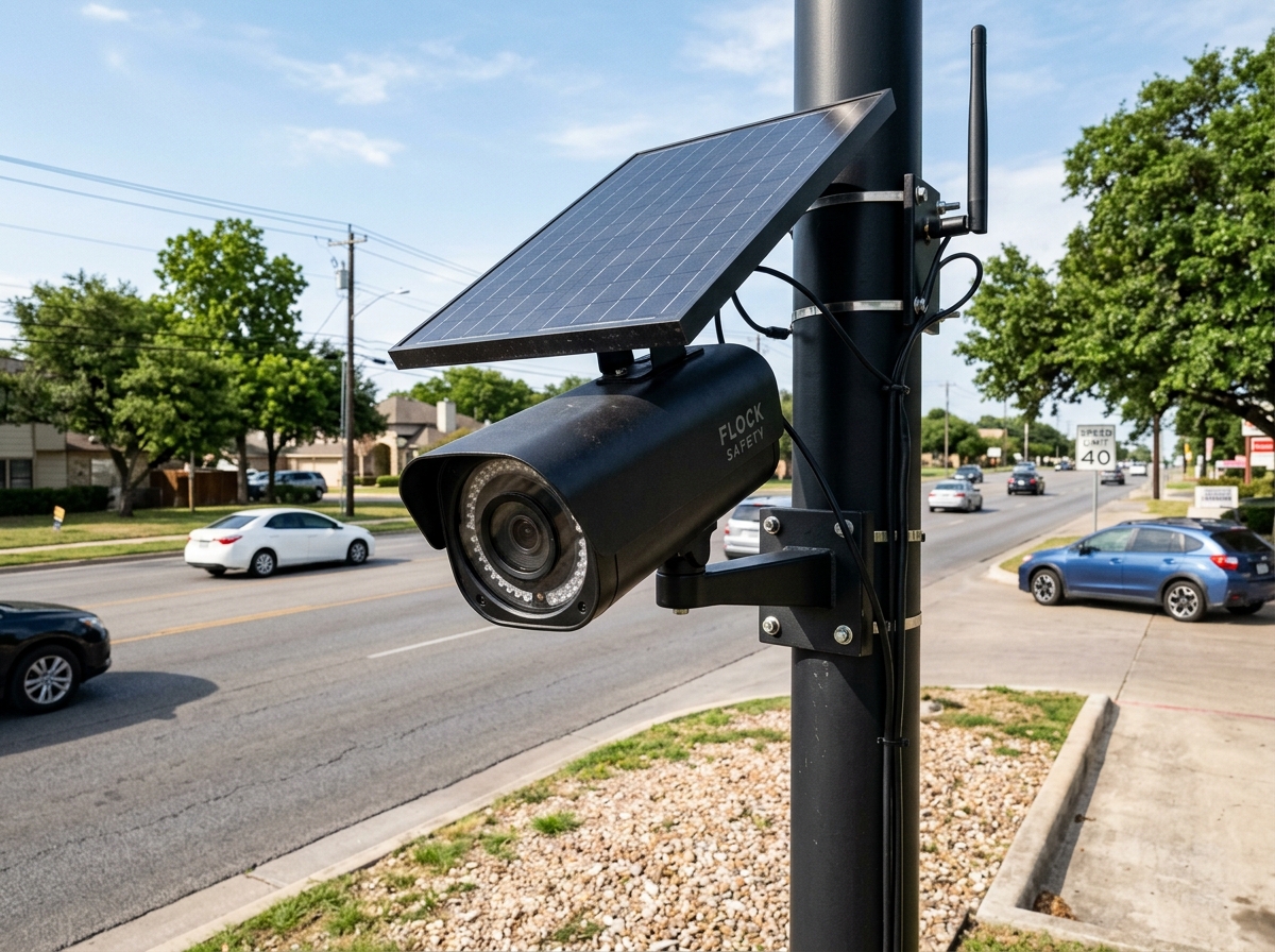
How to Spot a Flock Camera Location in Plain View
Flock Safety Falcon cameras have a standardized physical profile designed for rapid deployment without municipal trenching:
- Round Matte Black Post: Mounted 10 to 14 feet above grade on a dedicated steel pole, streetlight, or utility standard.
- 25-Watt Solar Array: A compact rectangular overhead solar panel tilted at 30° to 45° to catch maximum daylight.
- Cylindrical Sensor Housing: A compact black canister containing dual lenses (high-resolution color RGB and infrared) aimed toward oncoming traffic bumpers.
- Nighttime 850nm Glow: At dusk and nighttime, an invisible infrared strobe fires, showing a faint dull cherry-red LED reflection.
01.The Anatomy of Flock Camera Locations: Where Are They Installed?
Law enforcement agencies and municipal planners do not deploy Flock cameras randomly. Deployments follow a strategic doctrine designed to maximize vehicular capture rates while creating geographic containment perimeters. The primary categories of Flock camera locations include:
Arterial Commuter Bottlenecks
High-capacity boulevards, multi-lane parkways, and river crossing bridges where traffic funneling guarantees nearly 100% vehicle capture. Multiple cameras are staggered to capture every directional lane.
Highway Ingress & Egress Ramps
Interstate and state highway exit ramps. These locations allow police to intercept stolen vehicles and AMBER alert targets as they transition from high-speed freeways into municipal surface streets.
Municipal Perimeter Ring Gates
Suburban jurisdictions deploy concentric "virtual gates" along their city boundary limits, photographing every vehicle that enters or exits the municipal jurisdiction, effectively creating a persistent border audit log.
Subdivision & HOA Entrances
Private neighborhood entryways and cul-de-sac gateways. Homeowners Associations lease Falcon units to log all resident, delivery, and guest vehicles, feeding records into regional police hotlists.
02.Public vs. Private Flock Camera Locations: The HOA-to-Police Pipeline
One of the most consequential developments in modern surveillance is the privatization of ALPR networks. While municipal police departments are constrained by city council budget approvals and public procurement hearings, private entities face no such oversight:
When a private Homeowners Association or commercial shopping plaza installs a Flock camera, they enter into a Master Services Agreement with Flock Group Inc. Flock provides an opt-in checkbox enabling the HOA to federate its live video and plate detections directly to local law enforcement dispatchers through the TALON network. Because the cameras are privately owned, police gain warrantless access to residential vehicular movement without having to obtain Fourth Amendment search warrants or publish public surveillance impact reports.
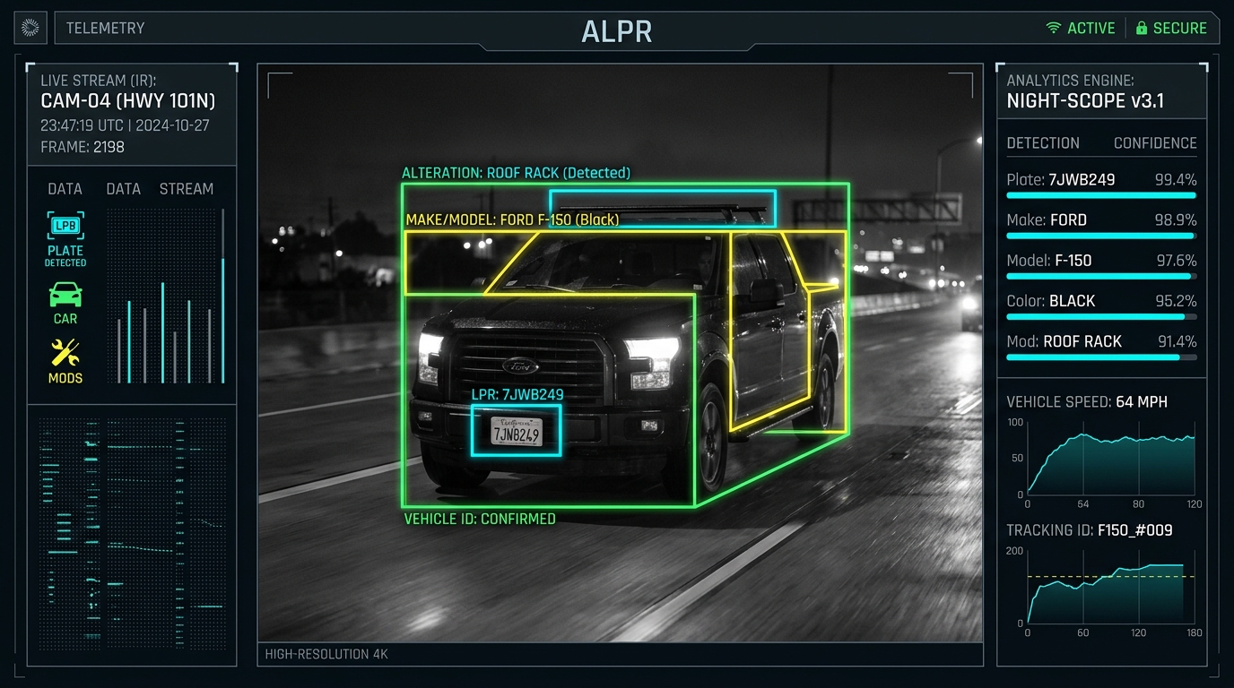
Vehicle Fingerprint™ AI at Camera Locations
Flock camera locations do far more than read alphanumeric plate characters. Every passing vehicle triggers a high-speed inference pipeline powered by Ambarella CV25 edge vision chips:
03.How Flock Camera Locations Are Mapped and Verified
Unlike commercial vendors who keep their deployment locations confidential, FlockCamerasMap utilizes a transparent, 4-stage data verification protocol based on open civic data:
OpenStreetMap Physical Ground Surveys
Field volunteers document physical roadside hardware using GPS mapping tools, tagging precise coordinates with standardized surveillance tags (`man_made=surveillance`, `surveillance:type=ALPR`, `camera:direction`).
Municipal Public Records & FOIA Contract Extraction
City council meeting minutes, police department procurement resolutions, and municipal Master Services Agreements frequently include installation schedules, utility pole permits, and intersection lists.
Satellite & Street-Level Visual Corroboration
High-resolution aerial imagery and municipal right-of-way street views verify solar panel orientation, pole alignment, and cross-street azimuth headings to ensure spatial fidelity.
Azimuth Heading & Traffic Lane Calculation
Every camera pin is assigned an azimuth angle (0° to 359°), indicating the exact compass direction the camera lens faces to track oncoming or departing vehicular flow.
04.Are Flock Camera Locations Public Information? State Legal Precedents
When citizens and investigative reporters file public records requests seeking Flock camera locations, police departments frequently resist disclosure, claiming that revealing camera sites would "compromise tactical law enforcement operations." However, state courts and open government statutes have consistently rejected these blanket secrecy claims:
The Landmark Ruling: EFF v. Los Angeles Police Department
In Electronic Frontier Foundation v. Superior Court (LAPD), the California Supreme Court ruled that ALPR data and records do not qualify for California’s broad "records of investigations" exemption. Because ALPR cameras record every motorist regardless of suspicion, they are automated surveillance grids rather than targeted investigations. Subsequent statutory reforms—such as California Senate Bill 34 (SB 34)—specifically mandate that agencies operating ALPR systems maintain an explicit public privacy policy, disclose operating custody, and publish usage logs.
Similarly, under the Texas Public Information Act (PIA), Florida Sunshine Law (Chapter 119), and Georgia Open Records Act, contracts between municipal councils and Flock Safety, monthly fee invoices, and pole permit attachments are indisputably public documents subject to mandatory disclosure upon request.
05.Flock Camera Deployment Category Comparison Matrix
Flock camera locations vary widely depending on who procured the hardware and where it is mounted. The table below outlines operational characteristics across the five primary deployment categories:
| Deployment Entity | Typical Location | Power Source | Data Retention | Public FOIA Subject? |
|---|---|---|---|---|
| Municipal Police | City thoroughfares & intersections | Solar (25W) or AC streetlight | 30 days (default) to 1 year | Yes (State FOIA) |
| County Sheriff | Unincorporated highway corridors | Dedicated solar pole | 30 to 90 days | Yes (County Clerk) |
| State DOT / Highway Patrol | Freeway off-ramps & weigh stations | Grid hardwire / Heavy solar | State statutory cap (e.g. 21-60 days) | Yes (State Records) |
| Residential HOA | Subdivision gates & entry medians | Solar panel on private median | 30 days via Flock cloud | Exempt (Unless shared with police) |
| Commercial Retail Plazas | Big box parking lot entrances | Parking light standard mount | 30 days via corporate security | No (Private Property) |