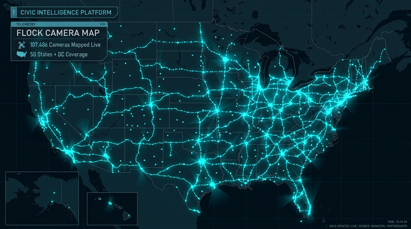
Flock Camera Map: Live Map of 150,071 Flock Safety Cameras & Locations
Welcome to the definitive Flock Camera Map, indexing over 150,071 community-documented Flock Safety cameras and automated license plate readers across the United States. Search your neighborhood, explore state-by-state coverage, and review camera operating agencies, vision angles, and statutory privacy regulations.
Live Flock Camera Map GIS Explorer
Zoom into any metro area or highway to load verified camera points, vision cones, and operating agencies in real time.
Loading Live Flock Camera Map GIS Database...
Streaming 150,071 authentic spatial coordinates
Camera data © OpenStreetMap contributors. Updated continuously. Community-reported and non-partisan.
Community-verified points across all 50 states
83,315+ explicitly confirmed Flock Falcon devices
Police departments, sheriffs, state patrols & HOAs
Every US jurisdiction with statutory legal summaries
100% Real Spatial Map
Every coordinate is derived from real physical roadside field audits, OpenStreetMap ODbL data, and municipal council contracts. Zero synthetic or fabricated points.
Vehicle Fingerprint™ AI
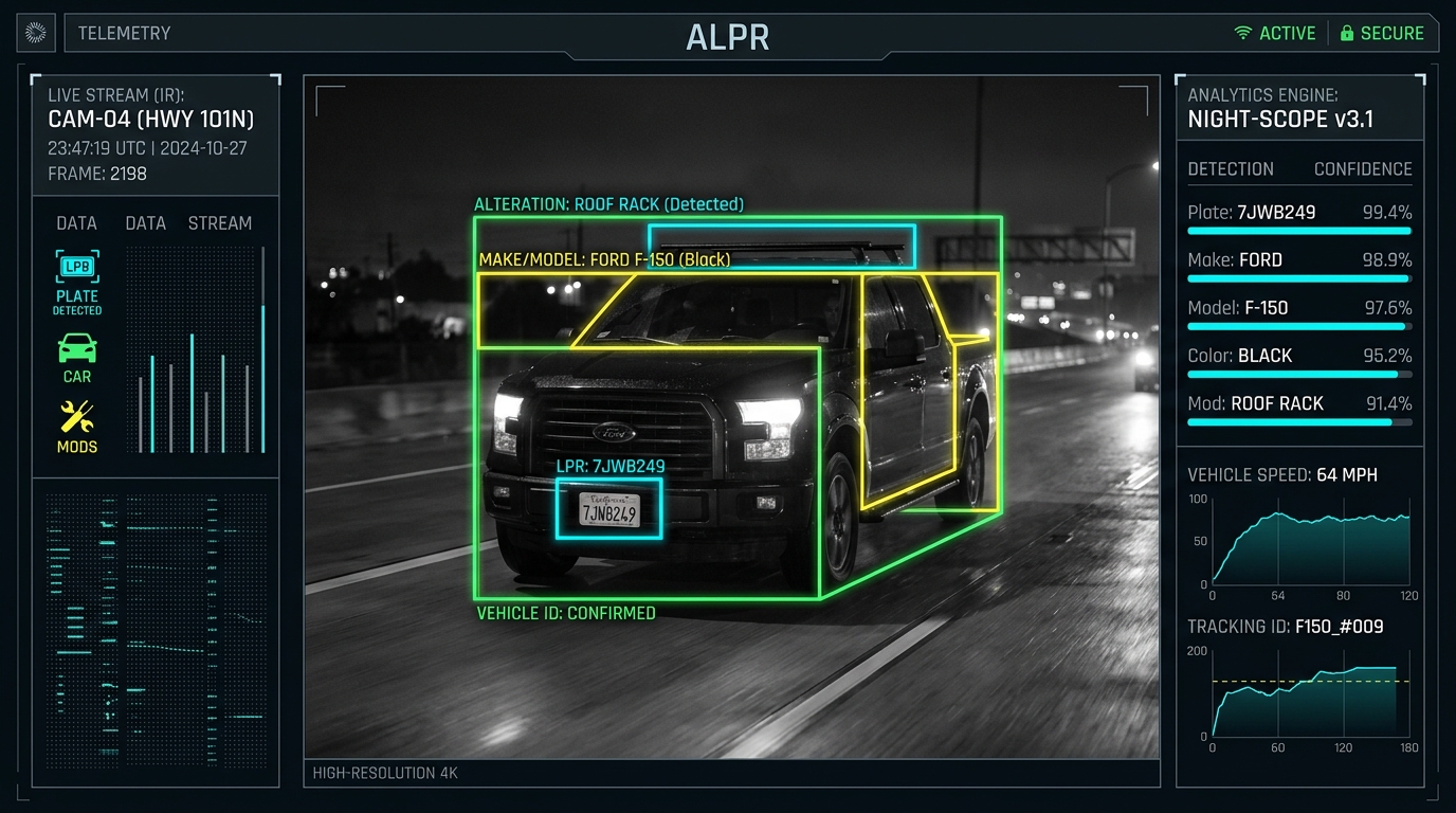
Machine vision extracts license plate characters, state origin, color, make, model, roof racks, bumper stickers, dents, and missing front plates in real time.
Statutory Privacy Tracker
State-by-state analysis of ALPR data retention caps (10 to 90 days), cross-jurisdiction sharing restrictions, and Fourth Amendment transparency benchmarks.
The HOA-Police Network
Examines how 3,000+ privately funded neighborhood cameras bridge residential perimeters into municipal law enforcement dispatch hotlists without warrants.
Live, Open Data
Every camera coordinate is derived from real physical roadside field audits, OpenStreetMap ODbL data, and municipal council contracts. Zero synthetic or paywalled points.
Every State, One Map
From California (15,364) to Texas (12,120) to Georgia (6,441), explore Flock camera locations in all 50 states + DC—or calculate cameras within 5 miles of you.
Simple by Design
One unified high-contrast map, electric cyan dots, directional azimuth rays, and plain-English answers to constitutional, hardware, and statutory questions.
National State Directory
Flock Camera Locations by State
Pick a state to view its cameras on the live map, discover the cities where they are most heavily reported, and review statutory data retention laws. Or access the complete Flock Camera Locations Master Database covering all 150,071+ geocoded installations.
- Alabama4,300
- Alaska6
- Arizona2,694
- Arkansas2,200
- California21,800
- Colorado2,690
- Connecticut1,125
- Delaware610
- District of Columbia296
- Florida9,197
- Georgia10,167
- Hawaii89
- Idaho531
- Illinois9,394
- Indiana4,495
- Iowa1,007
- Kansas2,330
- Kentucky1,338
- Louisiana2,843
- Maine68
- Maryland1,795
- Massachusetts1,535
- Michigan5,565
- Minnesota2,028
- Mississippi220
- Missouri1,703
- Montana41
- Nebraska352
- Nevada1
- New Hampshire67
- New Jersey4,328
- New Mexico1,361
- New York4,019
- North Carolina5,114
- North Dakota95
- Ohio6,613
- Oklahoma1,896
- Oregon776
- Pennsylvania2,175
- Rhode Island0
- South Carolina470
- South Dakota33
- Tennessee1,745
- Texas15,941
- Utah1,064
- Vermont0
- Virginia2,527
- Washington2,045
- West Virginia58
- Wisconsin0
- Wyoming68
Metropolitan Grids
Major Metropolitan Flock Camera Maps
Counts reflect cameras reported in each jurisdiction to date. Also explore all states overview and major cities directory.
Civic Knowledge Base
Definitive Guides to Flock Safety & ALPR Systems
Plain-English, fact-checked investigations into hardware specs, privacy laws, municipal pricing, and how community mapping projects operate.
What Is a Flock Camera? Complete Technical, Hardware & Operational Guide (2026)
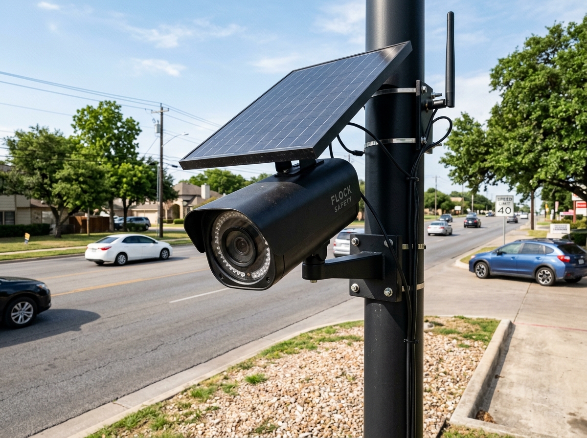
A Flock camera is a pole-mounted, solar-powered automated license plate recognition (ALPR) camera manufactured by Flock Safety that uses edge computer vision to photograph passing vehicles and catalog license plates, vehicle color, make, model, and distinguishing alterations into an encrypted searchable police database.
What Does a Flock Camera Look Like? Photos & Field Identification Guide
A Flock camera is easily distinguished by its matte black cylindrical chassis mounted 10 to 14 feet high on a standalone round metal pole, positioned directly beneath a small angled rectangular solar panel with zero ground electrical conduit.
Are Flock Camera Locations Public? Public Records, FOIA & Transparency Portals
While Flock Safety and police departments do not publish live national interactive maps, municipal contracts, installation invoices, and GPS coordinates are public government records subject to state open records laws.
How to Find Flock Cameras Near You: Live Maps, Citizen Audits & FOIA Records
Citizens can locate Flock Safety cameras in their area using four proven methods: live community GIS maps, physical field surveys, city council contract records, and open records requests.
How to Report a Flock Camera You Found: Field Tagging & Verification Guide
Citizens who spot an unmapped Flock camera can add it to the global transparency network using mobile OpenStreetMap apps (Go Map!!, Every Door) or by submitting verified coordinates directly.
DeFlock, FlockHopper & Flock Camera Maps Compared: Definitive 2026 Audit
A detailed comparison of civic surveillance mapping platforms, analyzing dataset accuracy, map rendering performance, search capabilities, and privacy protections.
How Much Does a Flock Camera Cost? Pricing, Contracts & Municipal Budgets
Flock Safety charges between $2,500 and $3,000 per camera annually on multi-year subscription contracts, with a one-time installation fee of $350 to $650 per pole.
Who Can Access Flock Camera Data? Police, HOAs, TALON & Fusion Centers
Flock camera data is accessed by municipal police departments, county sheriffs, state highway patrols, federal task forces, and private HOA property managers who purchase or share camera networks.
Understanding the Nationwide Flock Camera Map Network
Across the United States, automated license plate reader (ALPR) technology has undergone a rapid, unprecedented paradigm shift. Historically, license plate recognition was restricted to specialized police cruisers equipped with bulky roof-mounted cameras costing $20,000 to $30,000 or high-speed toll gantries on turnpikes. Starting in 2017, Atlanta-based Flock Safety fundamentally restructured the civic surveillance marketplace by introducing a lightweight, solar-powered, subscription-based device: the Flock Falcon.
Today, our open-source Flock Camera Map documents over 150,071 community-verified ALPR installations across all 50 states. Over 77% (83,315+ units) are confirmed Flock Safety hardware devices. Unlike traditional law enforcement tools, Flock cameras are not solely operated by city police departments and county sheriffs; thousands are purchased directly by private homeowners associations (HOAs), gated subdivisions, shopping malls, and corporate business improvement districts that federate their camera feeds directly into police dispatch centers.
How to Visually Identify a Flock Camera in the Field
Citizens and civic researchers frequently spot Flock Safety cameras installed along public roadways, neighborhood entrances, and school zones. A typical Flock Falcon installation exhibits distinct physical characteristics:
A compact, weather-sealed aluminum body angled downward toward oncoming traffic, housing an optical sensor and an 850nm infrared illuminator.
A compact 20W–40W rectangular solar panel mounted 1 to 2 feet above the camera head, angled toward the sun to trickle-charge an internal battery.
Typically anchored directly into roadside dirt or concrete curbs using break-away ground anchor bolts, with zero external power conduits running to the earth.
An embedded multi-carrier LTE antenna that transmits encrypted plate reads to Amazon Web Services (AWS) GovCloud in under 2 seconds.
The Vehicle Fingerprint™ Machine Vision Architecture
What makes Flock Safety distinct from legacy ALPR manufacturers is its proprietary Vehicle Fingerprint™ software pipeline. While traditional cameras only extract raw alphanumeric license plate characters, Flock devices capture an extensive contextual footprint:
- License Plate OCR & State Recognition: Reads standard state plates, specialty vanity plates, dealer paper tags, and out-of-state characters at vehicle speeds between 0 and 100 mph.
- Missing Plate Deduction: When a vehicle drives past with a missing front or rear plate, the neural network flags the absence as an investigative attribute.
- Secondary Visual Attributes: Classifies vehicle color, body style (sedan, SUV, pickup, coupe, van), roof racks, bike carriers, tow hitches, tinted windows, and aftermarket modifications.
- Custom Decals & Damage: Indexes unique bumper stickers, commercial lettering, missing hubcaps, and exterior body dents—enabling investigators to search queries such as "Red Honda Civic with roof rack and rear bumper dent" even without a known plate number.
Comprehensive Technical Comparison: Flock vs. Motorola vs. Genetec
| Feature Vector | Flock Safety Falcon | Motorola Solutions (Vigilant) | Genetec AutoVu |
|---|---|---|---|
| Business Model | SaaS Subscription ($3,000/yr per unit) | Capital Purchase ($15k–$25k) + Maintenance | Capital Purchase ($12k–$20k) + Licensing |
| Power Infrastructure | Integrated 20W Solar + LiFePO4 Battery | Hardwired 120V AC Municipal Grid Power | Hardwired 120V/240V AC Grid Power |
| Network Telemetry | Built-in Multi-Carrier 4G LTE SIM | Fiber Optic, Ethernet, or External Modem | Fiber Optic or Cellular Router |
| Vehicle Matching | Plate OCR + Vehicle Fingerprint AI Traits | High-Precision Plate OCR | Multi-Lane Plate OCR |
| HOA & Commercial Integration | Seamless Turnkey Portal Sharing | Enterprise Federation (Complex) | Enterprise Federation (Complex) |
| Default Cloud Retention | 30 Days (AWS GovCloud) | Agency Defined (Often 1–5 Years) | Agency Defined / On-Premise Server |
Major Metropolitan Camera Hubs
Metropolitan areas often deploy dense grids of ALPR cameras across major intersections, commercial centers, and residential perimeters.
Houston
4,909mapped
Atlanta
4,414mapped
Los Angeles
3,572mapped
Dallas
2,925mapped
Chicago
2,394mapped
Kansas City
1,456mapped
Detroit
1,451mapped
Fort Worth
1,327mapped
Frequently Asked Questions About Flock Cameras
Everything you need to know about ALPR cameras, live maps, privacy, and technology.